
 Puerto de la Duquesa
La Serna de Iguña
Pumalverde
Puentenansa
La Iglesia
Casar de Periedo
Fuengirola
Renedo de Piélagos
Villabanez
Puerto de la Duquesa
La Serna de Iguña
Pumalverde
Puentenansa
La Iglesia
Casar de Periedo
Fuengirola
Renedo de Piélagos
Villabanez
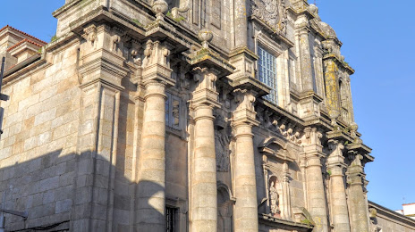
Igrexa de San Bartolomeu on the map, Pontevedra, Spain
Photo
Where is located Igrexa de San Bartolomeu
Igrexa de San Bartolomeu — local attraction, which is located at Calle Padre Sarmiento, 51, 36002 Pontevedra, Spain and belongs to the category — catholic church. Average visitor rating for this place — 4.4 (according to 316 ratings, information from open sources and relevant for 2022).
Exact location — Igrexa de San Bartolomeu, marked on the map with a red marker.
You can get directions to Igrexa de San Bartolomeu on the map from your location.
What else is interesting in Pontevedra? You can see all the sights if you go to the city page.
Coordinates
Igrexa de San Bartolomeu, Spain coordinates in decimal format: latitude — 42.43301994551226, longitude — -8.642564374991945. When converted to degrees, minutes, seconds Igrexa de San Bartolomeu has the following coordinates: 42°25′58.87 north latitude and -8°38′33.23 east longitude.
Nearby cities
The largest cities that are located nearby:
- Vigo — 22 km
- Ourense — 65 km
- Braga
 (Portugal) — 99 km
 - A Coruña — 105 km
- Porto (Portugal) — 141 km
- Coimbra (Portugal) — 247 km
- Oviedo — 247 km
- León — 251 km
- Gijón — 268 km
- Salamanca — 297 km
- Valladolid — 335 km
- Santander — 404 km
- Burgos — 404 km
- Amadora (Portugal) — 409 km
- Queluz (Portugal) — 409 km
- Lisbon (Portugal) — 412 km
- Badajoz — 418 km
- Móstoles — 465 km
- Alcorcón — 467 km
Distance to the capital
Distance to the capital (Madrid) is about — 469 km.