
 Józefów nad Wisłą
Gorzyce Wielkie
Rogówek
Sromowce Niżne
Wyszków County
Kruszewo
Jantar
Sady Górne
Nagoszewo
Józefów nad Wisłą
Gorzyce Wielkie
Rogówek
Sromowce Niżne
Wyszków County
Kruszewo
Jantar
Sady Górne
Nagoszewo
Ranczo Arka on the map, Lubartow, Poland
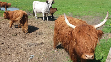
Photo
Where is located Ranczo Arka
Ranczo Arka — local attraction, which is located at Serniki 1c, 21-107 Serniki, Poland and belongs to the category — ranch. Average visitor rating for this place — 4.5 (according to 386 ratings, information from open sources and relevant for 2022).
Exact location — Ranczo Arka, marked on the map with a red marker.
You can get directions to Ranczo Arka on the map from your location.
What else is interesting in Lubartow? You can see all the sights if you go to the city page.
Coordinates
Ranczo Arka, Poland coordinates in decimal format: latitude — 51.43222668010211, longitude — 22.660184825316694. When converted to degrees, minutes, seconds Ranczo Arka has the following coordinates: 51°25′56.02 north latitude and 22°39′36.67 east longitude.
Nearby cities
The largest cities that are located nearby:
- Lublin — 24 km
- Radom — 101 km
- Brest
 (Belarus) — 104 km
 - Kielce — 153 km
- Rzeszow — 163 km
- Bialystok — 189 km
- Tarnow — 197 km
- Łódź — 218 km
- Plock — 229 km
- Kraków — 244 km
- Pinsk (Belarus) — 247 km
- Częstochowa — 254 km
- Wloclawek — 272 km
- Rivne
 (Ukraine) — 272 km
 - Dabrowa Gornicza — 272 km
- Sosnowiec — 280 km
- Katowice — 286 km
- Bytom — 288 km
- Chorzow — 288 km
Distance to the capital
Distance to the capital (Warsaw) is about — 144 km.