
 Józefów nad Wisłą
Gorzyce Wielkie
Rogówek
Sromowce Niżne
Wyszków County
Kruszewo
Jantar
Sady Górne
Nagoszewo
Józefów nad Wisłą
Gorzyce Wielkie
Rogówek
Sromowce Niżne
Wyszków County
Kruszewo
Jantar
Sady Górne
Nagoszewo
Museum of Archaeology and History in Glogow on the map, Glogow, Poland
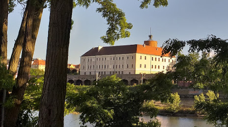
Photo
Where is located Museum of Archaeology and History in Glogow
Museum of Archaeology and History in Glogow — local attraction, which is located at Brama Brzostowska 1, 67-200 Głogów, Poland and belongs to the category — archaeological museum. Average visitor rating for this place — 4.5 (according to 268 ratings, information from open sources and relevant for 2022).
Exact location — Museum of Archaeology and History in Glogow, marked on the map with a red marker.
You can get directions to Museum of Archaeology and History in Glogow on the map from your location.
What else is interesting in Glogow? You can see all the sights if you go to the city page.
Coordinates
Museum of Archaeology and History in Glogow, Poland coordinates in decimal format: latitude — 51.667056335107695, longitude — 16.09069592532531. When converted to degrees, minutes, seconds Museum of Archaeology and History in Glogow has the following coordinates: 51°40′1.4 north latitude and 16°5′26.51 east longitude.
Nearby cities
The largest cities that are located nearby:
- Zielona Gora — 50 km
- Legnica — 51 km
- Wrocław — 90 km
- Walbrzych — 98 km
- Poznań — 100 km
- Cottbus
 (Germany) — 120 km
 - Gorzów Wielkopolski — 131 km
- Kalisz — 137 km
- Opole — 169 km
- Dresden (Germany) — 177 km
- Berlin (Germany) — 203 km
- Berlin (Germany) — 204 km
- Bydgoszcz — 206 km
- Prague
 (Czech Republic) — 211 km
 - Potsdam (Germany) — 219 km
- Szczecin — 220 km
- Torun — 224 km
- Wloclawek — 228 km
- Łódź — 231 km
Distance to the capital
Distance to the capital (Warsaw) is about — 343 km.