
 Józefów nad Wisłą
Gorzyce Wielkie
Rogówek
Sromowce Niżne
Wyszków County
Kruszewo
Jantar
Sady Górne
Nagoszewo
Józefów nad Wisłą
Gorzyce Wielkie
Rogówek
Sromowce Niżne
Wyszków County
Kruszewo
Jantar
Sady Górne
Nagoszewo
Miejski Park Rodzinny w Redzie on the map, Reda, Poland
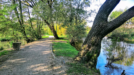
Photo
Where is located Miejski Park Rodzinny w Redzie
Miejski Park Rodzinny w Redzie — local attraction, which is located at 1 Maja, 84-240 Reda, Poland and belongs to the category — park. Average visitor rating for this place — 4.6 (according to 1460 ratings, information from open sources and relevant for 2022).
Exact location — Miejski Park Rodzinny w Redzie, marked on the map with a red marker.
You can get directions to Miejski Park Rodzinny w Redzie on the map from your location.
What else is interesting in Reda? You can see all the sights if you go to the city page.
Coordinates
Miejski Park Rodzinny w Redzie, Poland coordinates in decimal format: latitude — 54.606458717151654, longitude — 18.355651525435796. When converted to degrees, minutes, seconds Miejski Park Rodzinny w Redzie has the following coordinates: 54°36′23.25 north latitude and 18°21′20.35 east longitude.
Nearby cities
The largest cities that are located nearby:
- Gdynia — 15 km
- Gdańsk — 34 km
- Elblag — 85 km
- Kaliningrad
 (Russia) — 139 km
 - Koszalin — 148 km
- Bydgoszcz — 165 km
- Olsztyn — 167 km
- Torun — 177 km
- Klaipėda
 (Lithuania) — 212 km
 - Wloclawek — 222 km
- Plock — 245 km
- Poznań — 261 km
- Szczecin — 282 km
- Gorzów Wielkopolski — 294 km
- Kalisz — 314 km
- Łódź — 324 km
- Šiauliai (Lithuania) — 341 km
- Malmö
 (Sweden) — 352 km
 - Zielona Gora — 353 km
Distance to the capital
Distance to the capital (Warsaw) is about — 318 km.