
 Józefów nad Wisłą
Gorzyce Wielkie
Rogówek
Sromowce Niżne
Wyszków County
Kruszewo
Jantar
Sady Górne
Nagoszewo
Józefów nad Wisłą
Gorzyce Wielkie
Rogówek
Sromowce Niżne
Wyszków County
Kruszewo
Jantar
Sady Górne
Nagoszewo
Pałac Wolsztyn on the map, Wolsztyn, Poland
Photo
Where is located Pałac Wolsztyn
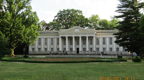
Pałac Wolsztyn — local attraction, which is located at Drzymały 4, 64-200 Wolsztyn, Poland and belongs to the category — tourist attraction. Average visitor rating for this place — 4.2 (according to 44 ratings, information from open sources and relevant for 2022).
Exact location — Pałac Wolsztyn, marked on the map with a red marker.
You can get directions to Pałac Wolsztyn on the map from your location.
What else is interesting in Wolsztyn? You can see all the sights if you go to the city page.
Coordinates
Pałac Wolsztyn, Poland coordinates in decimal format: latitude — 52.111305465179385, longitude — 16.113469060860645. When converted to degrees, minutes, seconds Pałac Wolsztyn has the following coordinates: 52°6′40.7 north latitude and 16°6′48.49 east longitude.
Nearby cities
The largest cities that are located nearby:
- Zielona Gora — 46 km
- Poznań — 63 km
- Gorzów Wielkopolski — 90 km
- Legnica — 100 km
- Cottbus
 (Germany) — 128 km
 - Wrocław — 128 km
- Kalisz — 140 km
- Walbrzych — 148 km
- Bydgoszcz — 168 km
- Szczecin — 178 km
- Berlin (Germany) — 188 km
- Berlin (Germany) — 188 km
- Torun — 193 km
- Dresden (Germany) — 203 km
- Opole — 203 km
- Wloclawek — 207 km
- Potsdam (Germany) — 208 km
- Koszalin — 230 km
- Łódź — 232 km
Distance to the capital
Distance to the capital (Warsaw) is about — 334 km.