
 Józefów nad Wisłą
Gorzyce Wielkie
Rogówek
Sromowce Niżne
Wyszków County
Kruszewo
Jantar
Sady Górne
Nagoszewo
Józefów nad Wisłą
Gorzyce Wielkie
Rogówek
Sromowce Niżne
Wyszków County
Kruszewo
Jantar
Sady Górne
Nagoszewo
Pałac w Żarskiej Wsi on the map, Zgorzelec, Poland
Photo
Where is located Pałac w Żarskiej Wsi
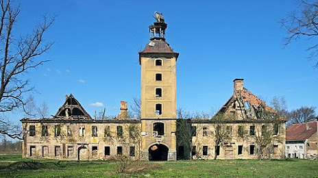
Pałac w Żarskiej Wsi — local attraction, which is located at Żarska Wieś 30, 59-900 Żarska Wieś, Poland and belongs to the category — historical landmark. Average visitor rating for this place — 3.8 (according to 20 ratings, information from open sources and relevant for 2022).
Exact location — Pałac w Żarskiej Wsi, marked on the map with a red marker.
You can get directions to Pałac w Żarskiej Wsi on the map from your location.
What else is interesting in Zgorzelec? You can see all the sights if you go to the city page.
Coordinates
Pałac w Żarskiej Wsi, Poland coordinates in decimal format: latitude — 51.19216172216493, longitude — 15.10090462530785. When converted to degrees, minutes, seconds Pałac w Żarskiej Wsi has the following coordinates: 51°11′31.78 north latitude and 15°6′3.26 east longitude.
Nearby cities
The largest cities that are located nearby:
- Legnica — 80 km
- Cottbus
 (Germany) — 81 km
 - Dresden (Germany) — 89 km
- Zielona Gora — 93 km
- Walbrzych — 98 km
- Prague
 (Czech Republic) — 125 km
 - Wrocław — 141 km
- Chemnitz (Germany) — 150 km
- Gorzów Wielkopolski — 176 km
- Leipzig (Germany) — 183 km
- Berlin (Germany) — 185 km
- Berlin (Germany) — 186 km
- Potsdam (Germany) — 190 km
- Poznań — 190 km
- Pilsen (Czech Republic) — 195 km
- Gera (Germany) — 206 km
- Opole — 211 km
- Kalisz — 221 km
- Olomouc (Czech Republic) — 236 km
Distance to the capital
Distance to the capital (Warsaw) is about — 423 km.