
 Józefów nad Wisłą
Gorzyce Wielkie
Rogówek
Sromowce Niżne
Wyszków County
Kruszewo
Jantar
Sady Górne
Nagoszewo
Józefów nad Wisłą
Gorzyce Wielkie
Rogówek
Sromowce Niżne
Wyszków County
Kruszewo
Jantar
Sady Górne
Nagoszewo
Limanowski Krzyż - Chłopska Góra on the map, Limanowa, Poland
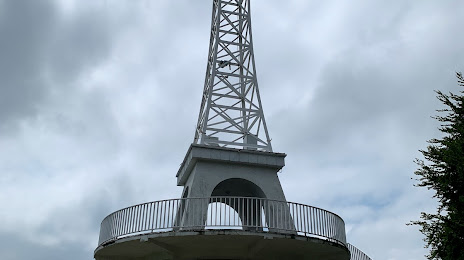
Photo
Where is located Limanowski Krzyż - Chłopska Góra
Limanowski Krzyż - Chłopska Góra — local attraction, which is located at 34-600 Limanowa, Poland and belongs to the category — vista point. Average visitor rating for this place — 4.8 (according to 541 rating, information from open sources and relevant for 2022).
Exact location — Limanowski Krzyż - Chłopska Góra, marked on the map with a red marker.
You can get directions to Limanowski Krzyż - Chłopska Góra on the map from your location.
What else is interesting in Limanowa? You can see all the sights if you go to the city page.
Coordinates
Limanowski Krzyż - Chłopska Góra, Poland coordinates in decimal format: latitude — 49.71888376467246, longitude — 20.440602525254477. When converted to degrees, minutes, seconds Limanowski Krzyż - Chłopska Góra has the following coordinates: 49°43′7.98 north latitude and 20°26′26.17 east longitude.
Nearby cities
The largest cities that are located nearby:
- Kraków — 52 km
- Tarnow — 52 km
- Bielsko-Biala — 98 km
- Dabrowa Gornicza — 110 km
- Sosnowiec — 113 km
- Katowice — 117 km
- Rzeszow — 118 km
- Chorzow — 123 km
- Košice
 (Slovakia) — 125 km
 - Ruda Slaska — 126 km
- Bytom — 128 km
- Kielce — 129 km
- Zabrze — 134 km
- Gliwice — 140 km
- Rybnik — 140 km
- Częstochowa — 152 km
- Ostrava
 (Czech Republic) — 155 km
 - Miskolc
 (Hungary) — 180 km
 - Uzhhorod
 (Ukraine) — 182 km
Distance to the capital
Distance to the capital (Warsaw) is about — 282 km.