
 Józefów nad Wisłą
Gorzyce Wielkie
Rogówek
Sromowce Niżne
Wyszków County
Kruszewo
Jantar
Sady Górne
Nagoszewo
Józefów nad Wisłą
Gorzyce Wielkie
Rogówek
Sromowce Niżne
Wyszków County
Kruszewo
Jantar
Sady Górne
Nagoszewo
Ostróda Museum on the map, Ostroda, Poland
Photo
Where is located Ostróda Museum
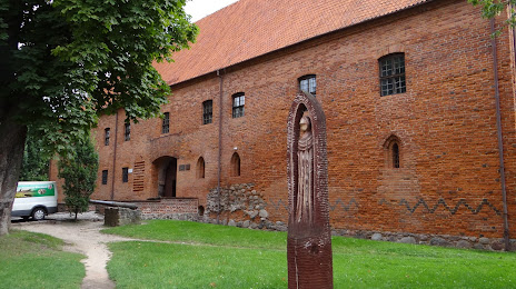
Ostróda Museum — local attraction, which is located at Adama Mickiewicza 22, 14-100 Ostróda, Poland and belongs to the category — museum. Average visitor rating for this place — 4.4 (according to 33 ratings, information from open sources and relevant for 2022).
Exact location — Ostróda Museum, marked on the map with a red marker.
You can get directions to Ostróda Museum on the map from your location.
What else is interesting in Ostroda? You can see all the sights if you go to the city page.
Coordinates
Ostróda Museum, Poland coordinates in decimal format: latitude — 53.70184494355183, longitude — 19.95092339960721. When converted to degrees, minutes, seconds Ostróda Museum has the following coordinates: 53°42′6.64 north latitude and 19°57′3.32 east longitude.
Nearby cities
The largest cities that are located nearby:
- Olsztyn — 35 km
- Elblag — 62 km
- Gdańsk — 112 km
- Torun — 118 km
- Kaliningrad
 (Russia) — 118 km
 - Plock — 128 km
- Gdynia — 129 km
- Wloclawek — 131 km
- Bydgoszcz — 144 km
- Łódź — 217 km
- Bialystok — 222 km
- Klaipėda
 (Lithuania) — 234 km
 - Kalisz — 249 km
- Poznań — 250 km
- Koszalin — 251 km
- Radom — 266 km
- Kaunas (Lithuania) — 284 km
- Brest
 (Belarus) — 311 km
 - Kielce — 316 km
Distance to the capital
Distance to the capital (Warsaw) is about — 179 km.