
 Józefów nad Wisłą
Gorzyce Wielkie
Rogówek
Sromowce Niżne
Wyszków County
Kruszewo
Jantar
Sady Górne
Nagoszewo
Józefów nad Wisłą
Gorzyce Wielkie
Rogówek
Sromowce Niżne
Wyszków County
Kruszewo
Jantar
Sady Górne
Nagoszewo
Mała Synagoga we Włodawie on the map, Wlodawa, Poland
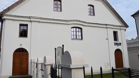
Photo
Where is located Mała Synagoga we Włodawie
Mała Synagoga we Włodawie — local attraction, which is located at Czerwonego Krzyża 7, 22-200 Włodawa, Poland and belongs to the category — historical landmark. Average visitor rating for this place — 4.6 (according to 33 ratings, information from open sources and relevant for 2022).
Exact location — Mała Synagoga we Włodawie, marked on the map with a red marker.
You can get directions to Mała Synagoga we Włodawie on the map from your location.
What else is interesting in Wlodawa? You can see all the sights if you go to the city page.
Coordinates
Mała Synagoga we Włodawie, Poland coordinates in decimal format: latitude — 51.5448302543659, longitude — 23.55364852532072. When converted to degrees, minutes, seconds Mała Synagoga we Włodawie has the following coordinates: 51°32′41.39 north latitude and 23°33′13.13 east longitude.
Nearby cities
The largest cities that are located nearby:
- Brest
 (Belarus) — 62 km
 - Lublin — 76 km
- Radom — 167 km
- Bialystok — 177 km
- Pinsk (Belarus) — 183 km
- Rzeszow — 200 km
- Rivne
 (Ukraine) — 215 km
 - Kielce — 218 km
- Baranovichi (Belarus) — 238 km
- Tarnow — 250 km
- Plock — 281 km
- Łódź — 281 km
- Salihorsk (Belarus) — 299 km
- Kraków — 304 km
- Olsztyn — 318 km
- Częstochowa — 320 km
- Wloclawek — 324 km
- Dabrowa Gornicza — 336 km
- Uzhhorod (Ukraine) — 337 km
Distance to the capital
Distance to the capital (Warsaw) is about — 190 km.