
 Józefów nad Wisłą
Gorzyce Wielkie
Rogówek
Sromowce Niżne
Wyszków County
Kruszewo
Jantar
Sady Górne
Nagoszewo
Józefów nad Wisłą
Gorzyce Wielkie
Rogówek
Sromowce Niżne
Wyszków County
Kruszewo
Jantar
Sady Górne
Nagoszewo
Falochron Zachodni Darłówko on the map, Darlowo, Poland
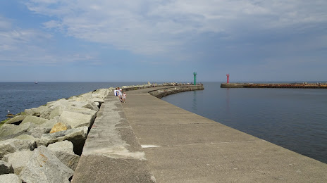
Photo
Where is located Falochron Zachodni Darłówko
Falochron Zachodni Darłówko — local attraction, which is located at 76-150, Darłowo, Poland and belongs to the category — scenic spot. Average visitor rating for this place — 4.7 (according to 67 ratings, information from open sources and relevant for 2022).
Exact location — Falochron Zachodni Darłówko, marked on the map with a red marker.
You can get directions to Falochron Zachodni Darłówko on the map from your location.
What else is interesting in Darlowo? You can see all the sights if you go to the city page.
Coordinates
Falochron Zachodni Darłówko, Poland coordinates in decimal format: latitude — 54.44154190394454, longitude — 16.37170422542939. When converted to degrees, minutes, seconds Falochron Zachodni Darłówko has the following coordinates: 54°26′29.55 north latitude and 16°22′18.14 east longitude.
Nearby cities
The largest cities that are located nearby:
- Koszalin — 29 km
- Gdynia — 136 km
- Gdańsk — 144 km
- Szczecin — 164 km
- Bydgoszcz — 178 km
- Elblag — 196 km
- Gorzów Wielkopolski — 203 km
- Torun — 213 km
- Poznań — 225 km
- Malmö
 (Sweden) — 250 km
 - Kaliningrad
 (Russia) — 264 km
 - Wloclawek — 265 km
- Olsztyn — 275 km
- Copenhagen
 (Denmark) — 277 km
 - Zielona Gora — 282 km
- Rostock
 (Germany) — 282 km
 - Berlin (Germany) — 292 km
- Berlin (Germany) — 294 km
- Plock — 303 km
Distance to the capital
Distance to the capital (Warsaw) is about — 394 km.