
 Józefów nad Wisłą
Gorzyce Wielkie
Rogówek
Sromowce Niżne
Wyszków County
Kruszewo
Jantar
Sady Górne
Nagoszewo
Józefów nad Wisłą
Gorzyce Wielkie
Rogówek
Sromowce Niżne
Wyszków County
Kruszewo
Jantar
Sady Górne
Nagoszewo
Muzeum Ziemi Złotowskiej on the map, Zlotow, Poland
Photo
Where is located Muzeum Ziemi Złotowskiej
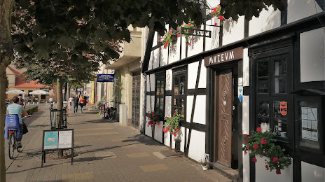
Muzeum Ziemi Złotowskiej — local attraction, which is located at Wojska Polskiego 2a, 77-400 Złotów, Poland and belongs to the category — local history museum. Average visitor rating for this place — 4.6 (according to 117 ratings, information from open sources and relevant for 2022).
Exact location — Muzeum Ziemi Złotowskiej, marked on the map with a red marker.
You can get directions to Muzeum Ziemi Złotowskiej on the map from your location.
What else is interesting in Zlotow? You can see all the sights if you go to the city page.
Coordinates
Muzeum Ziemi Złotowskiej, Poland coordinates in decimal format: latitude — 53.363485969702225, longitude — 17.036353825388517. When converted to degrees, minutes, seconds Muzeum Ziemi Złotowskiej has the following coordinates: 53°21′48.55 north latitude and 17°2′10.87 east longitude.
Nearby cities
The largest cities that are located nearby:
- Bydgoszcz — 70 km
- Poznań — 106 km
- Koszalin — 108 km
- Torun — 111 km
- Gorzów Wielkopolski — 139 km
- Gdańsk — 150 km
- Wloclawek — 157 km
- Gdynia — 160 km
- Szczecin — 164 km
- Elblag — 176 km
- Zielona Gora — 189 km
- Kalisz — 190 km
- Plock — 201 km
- Olsztyn — 229 km
- Łódź — 242 km
- Legnica — 246 km
- Wrocław — 249 km
- Cottbus
 (Germany) — 257 km
 - Berlin (Germany) — 262 km
Distance to the capital
Distance to the capital (Warsaw) is about — 296 km.