
 Józefów nad Wisłą
Gorzyce Wielkie
Rogówek
Sromowce Niżne
Wyszków County
Kruszewo
Jantar
Sady Górne
Nagoszewo
Józefów nad Wisłą
Gorzyce Wielkie
Rogówek
Sromowce Niżne
Wyszków County
Kruszewo
Jantar
Sady Górne
Nagoszewo
Muzeum Regionalne im. Wojciechy Dutkiewicz on the map, Rogozno, Poland
Photo
Where is located Muzeum Regionalne im. Wojciechy Dutkiewicz
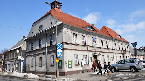
Muzeum Regionalne im. Wojciechy Dutkiewicz — local attraction, which is located at plac Marcinkowskiego 1, 64-610 Rogoźno, Poland and belongs to the category — museum. Average visitor rating for this place — 4.5 (according to 125 ratings, information from open sources and relevant for 2022).
Exact location — Muzeum Regionalne im. Wojciechy Dutkiewicz, marked on the map with a red marker.
You can get directions to Muzeum Regionalne im. Wojciechy Dutkiewicz on the map from your location.
What else is interesting in Rogozno? You can see all the sights if you go to the city page.
Coordinates
Muzeum Regionalne im. Wojciechy Dutkiewicz, Poland coordinates in decimal format: latitude — 52.7483499553118, longitude — 17.0041322253654. When converted to degrees, minutes, seconds Muzeum Regionalne im. Wojciechy Dutkiewicz has the following coordinates: 52°44′54.06 north latitude and 17°0′14.88 east longitude.
Nearby cities
The largest cities that are located nearby:
- Poznań — 38 km
- Bydgoszcz — 78 km
- Torun — 110 km
- Gorzów Wielkopolski — 118 km
- Kalisz — 131 km
- Zielona Gora — 136 km
- Wloclawek — 139 km
- Koszalin — 169 km
- Szczecin — 178 km
- Legnica — 180 km
- Wrocław — 182 km
- Plock — 183 km
- Łódź — 200 km
- Gdańsk — 206 km
- Cottbus
 (Germany) — 213 km
 - Gdynia — 219 km
- Elblag — 220 km
- Walbrzych — 223 km
- Opole — 238 km
Distance to the capital
Distance to the capital (Warsaw) is about — 277 km.