
 Gilserberg
Berlin
Bordesholm
Bechtolsheim
Aub
Triptis
Heppenheim
Biblis
Angermünde
Gilserberg
Berlin
Bordesholm
Bechtolsheim
Aub
Triptis
Heppenheim
Biblis
Angermünde
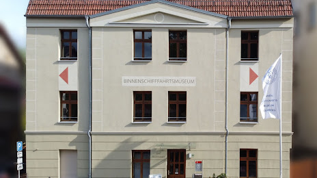
Binnenschifffahrts-Museum Oderberg on the map, Bad Freienwalde, Germany
Photo
Where is located Binnenschifffahrts-Museum Oderberg
Binnenschifffahrts-Museum Oderberg — local attraction, which is located at Hermann-Seidel-Straße 44, 16248 Oderberg, Germany and belongs to the category — museum. Average visitor rating for this place — 4.5 (according to 62 ratings, information from open sources and relevant for 2022).
Exact location — Binnenschifffahrts-Museum Oderberg, marked on the map with a red marker.
You can get directions to Binnenschifffahrts-Museum Oderberg on the map from your location.
What else is interesting in Bad Freienwalde? You can see all the sights if you go to the city page.
Coordinates
Binnenschifffahrts-Museum Oderberg, Germany coordinates in decimal format: latitude — 52.86318543241642, longitude — 14.046026425369707. When converted to degrees, minutes, seconds Binnenschifffahrts-Museum Oderberg has the following coordinates: 52°51′47.47 north latitude and 14°2′45.7 east longitude.
Nearby cities
The largest cities that are located nearby:
- Berlin — 54 km
- Potsdam — 79 km
- Szczecin
 (Poland) — 79 km
 - Gorzów Wielkopolski (Poland) — 80 km
- Cottbus — 115 km
- Zielona Gora (Poland) — 137 km
- Magdeburg — 179 km
- Rostock — 192 km
- Dresden — 193 km
- Leipzig — 197 km
- Poznań (Poland) — 199 km
- Koszalin (Poland) — 208 km
- Wolfsburg — 223 km
- Legnica (Poland) — 228 km
- Chemnitz — 230 km
- Brunswick — 244 km
- Gera — 250 km
- Salzgitter — 261 km
- Bydgoszcz (Poland) — 266 km
Distance to the capital
Distance to the capital (Berlin) is about — 58 km.