
 Józefów nad Wisłą
Gorzyce Wielkie
Rogówek
Sromowce Niżne
Wyszków County
Kruszewo
Jantar
Sady Górne
Nagoszewo
Józefów nad Wisłą
Gorzyce Wielkie
Rogówek
Sromowce Niżne
Wyszków County
Kruszewo
Jantar
Sady Górne
Nagoszewo
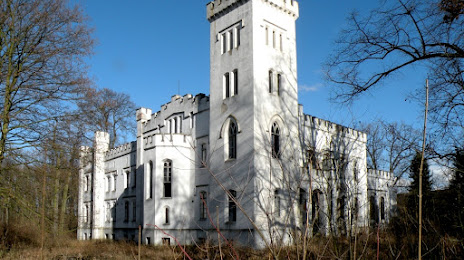
Pałac z 1854 roku rodziny Pfoertner von der Hoelle/ ob. własność prywatna on the map, Namysłów, Poland
Photo
Where is located Pałac z 1854 roku rodziny Pfoertner von der Hoelle/ ob. własność prywatna
Pałac z 1854 roku rodziny Pfoertner von der Hoelle/ ob. własność prywatna — local attraction, which is located at Łączany 7, 46-100 Łączany, Poland and belongs to the category — historical landmark. Average visitor rating for this place — 3.7 (according to 60 ratings, information from open sources and relevant for 2022).
Exact location — Pałac z 1854 roku rodziny Pfoertner von der Hoelle/ ob. własność prywatna, marked on the map with a red marker.
You can get directions to Pałac z 1854 roku rodziny Pfoertner von der Hoelle/ ob. własność prywatna on the map from your location.
What else is interesting in Namysłów? You can see all the sights if you go to the city page.
Coordinates
Pałac z 1854 roku rodziny Pfoertner von der Hoelle/ ob. własność prywatna, Poland coordinates in decimal format: latitude — 51.075878356359944, longitude — 17.693158347279038. When converted to degrees, minutes, seconds Pałac z 1854 roku rodziny Pfoertner von der Hoelle/ ob. własność prywatna has the following coordinates: 51°4′33.16 north latitude and 17°41′35.37 east longitude.
Nearby cities
The largest cities that are located nearby:
- Opole — 46 km
- Wrocław — 48 km
- Kalisz — 80 km
- Częstochowa — 102 km
- Walbrzych — 106 km
- Gliwice — 109 km
- Legnica — 110 km
- Zabrze — 112 km
- Bytom — 116 km
- Ruda Slaska — 121 km
- Chorzow — 122 km
- Rybnik — 122 km
- Katowice — 128 km
- Sosnowiec — 131 km
- Dabrowa Gornicza — 133 km
- Łódź — 141 km
- Ostrava
 (Czech Republic) — 144 km
 - Poznań — 157 km
- Olomouc (Czech Republic) — 167 km
Distance to the capital
Distance to the capital (Warsaw) is about — 263 km.