
 Puerto de la Duquesa
La Serna de Iguña
Pumalverde
Puentenansa
La Iglesia
Casar de Periedo
Fuengirola
Renedo de Piélagos
Villabanez
Puerto de la Duquesa
La Serna de Iguña
Pumalverde
Puentenansa
La Iglesia
Casar de Periedo
Fuengirola
Renedo de Piélagos
Villabanez
Cueva El Pendo on the map, Camargo, Spain
Photo
Where is located Cueva El Pendo
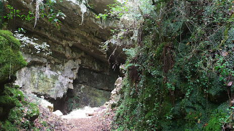
Cueva El Pendo — local attraction, which is located at Barrio el Churi, 39609 Escobedo, Cantabria, Spain and belongs to the category — cave. Average visitor rating for this place — 4.7 (according to 518 ratings, information from open sources and relevant for 2022).
Exact location — Cueva El Pendo, marked on the map with a red marker.
You can get directions to Cueva El Pendo on the map from your location.
What else is interesting in Camargo? You can see all the sights if you go to the city page.
Coordinates
Cueva El Pendo, Spain coordinates in decimal format: latitude — 43.38774679319631, longitude — -3.913507574961407. When converted to degrees, minutes, seconds Cueva El Pendo has the following coordinates: 43°23′15.89 north latitude and -3°54′48.63 east longitude.
Nearby cities
The largest cities that are located nearby:
- Santander — 9 km
- Bilbao — 78 km
- Vitoria-Gasteiz — 115 km
- Burgos — 118 km
- Gijón — 143 km
- San Sebastián — 153 km
- Logroño — 157 km
- Oviedo — 158 km
- León — 164 km
- Pamplona — 193 km
- Valladolid — 206 km
- Bordeaux
 (France) — 304 km
 - Salamanca — 308 km
- Zaragoza — 315 km
- Alcobendas — 318 km
- Alcala de Henares — 326 km
- Torrejón de Ardoz — 328 km
- Alcorcón — 338 km
- Leganés — 340 km
Distance to the capital
Distance to the capital (Madrid) is about — 331 km.