
 Puerto de la Duquesa
La Serna de Iguña
Pumalverde
Puentenansa
La Iglesia
Casar de Periedo
Fuengirola
Renedo de Piélagos
Villabanez
Puerto de la Duquesa
La Serna de Iguña
Pumalverde
Puentenansa
La Iglesia
Casar de Periedo
Fuengirola
Renedo de Piélagos
Villabanez
Cocentaina Castle on the map, Cocentaina, Spain
Photo
Where is located Cocentaina Castle
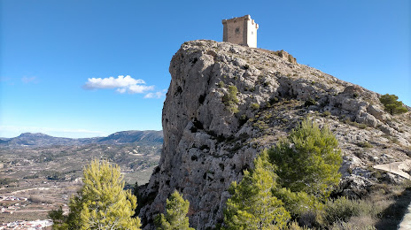
Cocentaina Castle — local attraction, which is located at Cami de l'Estacio Nord, 18, 03820 Cocentaina, Alicante, Spain and belongs to the category — castle. Average visitor rating for this place — 4.6 (according to 185 ratings, information from open sources and relevant for 2022).
Exact location — Cocentaina Castle, marked on the map with a red marker.
You can get directions to Cocentaina Castle on the map from your location.
What else is interesting in Cocentaina? You can see all the sights if you go to the city page.
Coordinates
Cocentaina Castle, Spain coordinates in decimal format: latitude — 38.74592352481752, longitude — -0.44759087510466977. When converted to degrees, minutes, seconds Cocentaina Castle has the following coordinates: 38°44′45.32 north latitude and -0°26′51.33 east longitude.
Nearby cities
The largest cities that are located nearby:
- Valencia — 80 km
- Murcia — 103 km
- Albacete — 125 km
- Cartagena — 133 km
- Almería — 277 km
- Palma — 279 km
- Tarragona — 298 km
- Jaén — 311 km
- Alcala de Henares — 312 km
- Torrejón de Ardoz — 318 km
- Zaragoza — 323 km
- Chlef
 (Algeria) — 326 km
 - Getafe — 327 km
- Granada — 328 km
- Lleida — 329 km
- Leganés — 331 km
- Fuenlabrada — 331 km
- Alcobendas — 334 km
- Alcorcón — 336 km
Distance to the capital
Distance to the capital (Madrid) is about — 335 km.