
 Puerto de la Duquesa
La Serna de Iguña
Pumalverde
Puentenansa
La Iglesia
Casar de Periedo
Fuengirola
Renedo de Piélagos
Villabanez
Puerto de la Duquesa
La Serna de Iguña
Pumalverde
Puentenansa
La Iglesia
Casar de Periedo
Fuengirola
Renedo de Piélagos
Villabanez
Torreón del Castillo on the map, Montilla, Spain
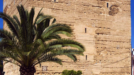
Photo
Where is located Torreón del Castillo
Torreón del Castillo — local attraction, which is located at C. Arco de la Villa, 14540 La Rambla, Córdoba, Spain and belongs to the category — castle. Average visitor rating for this place — 5.0 (according to 1 rating, information from open sources and relevant for 2022).
Exact location — Torreón del Castillo, marked on the map with a red marker.
You can get directions to Torreón del Castillo on the map from your location.
What else is interesting in Montilla? You can see all the sights if you go to the city page.
Coordinates
Torreón del Castillo, Spain coordinates in decimal format: latitude — 37.593762353109526, longitude — -4.697288463521425. When converted to degrees, minutes, seconds Torreón del Castillo has the following coordinates: 37°35′37.54 north latitude and -4°41′50.24 east longitude.
Nearby cities
The largest cities that are located nearby:
- Córdoba — 35 km
- Jaén — 77 km
- Málaga — 98 km
- Granada — 102 km
- Dos Hermanas — 118 km
- Marbella — 121 km
- Jerez — 165 km
- Algeciras — 176 km
- Cádiz — 188 km
- Huelva — 206 km
- Almería — 210 km
- Tangier
 (Morocco) — 229 km
 - Tetouan (Morocco) — 233 km
- Badajoz — 246 km
- Albacete — 285 km
- Fuenlabrada — 307 km
- Murcia — 309 km
- Nador (Morocco) — 309 km
- Móstoles — 309 km
Distance to the capital
Distance to the capital (Madrid) is about — 326 km.