
 Józefów nad Wisłą
Gorzyce Wielkie
Rogówek
Sromowce Niżne
Wyszków County
Kruszewo
Jantar
Sady Górne
Nagoszewo
Józefów nad Wisłą
Gorzyce Wielkie
Rogówek
Sromowce Niżne
Wyszków County
Kruszewo
Jantar
Sady Górne
Nagoszewo
Muzeum Regionalne w Kozienicach on the map, Kozienice, Poland
Photo
Where is located Muzeum Regionalne w Kozienicach
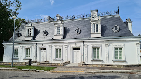
Muzeum Regionalne w Kozienicach — local attraction, which is located at Parkowa 5B, 26-900 Kozienice, Poland and belongs to the category — museum. Average visitor rating for this place — 4.6 (according to 38 ratings, information from open sources and relevant for 2022).
Exact location — Muzeum Regionalne w Kozienicach, marked on the map with a red marker.
You can get directions to Muzeum Regionalne w Kozienicach on the map from your location.
What else is interesting in Kozienice? You can see all the sights if you go to the city page.
Coordinates
Muzeum Regionalne w Kozienicach, Poland coordinates in decimal format: latitude — 51.58848898319093, longitude — 21.55369252532239. When converted to degrees, minutes, seconds Muzeum Regionalne w Kozienicach has the following coordinates: 51°35′18.56 north latitude and 21°33′13.29 east longitude.
Nearby cities
The largest cities that are located nearby:
- Radom — 34 km
- Lublin — 80 km
- Kielce — 102 km
- Łódź — 145 km
- Brest
 (Belarus) — 159 km
 - Plock — 163 km
- Rzeszow — 174 km
- Tarnow — 179 km
- Częstochowa — 190 km
- Bialystok — 202 km
- Kraków — 203 km
- Wloclawek — 204 km
- Dabrowa Gornicza — 217 km
- Sosnowiec — 225 km
- Katowice — 231 km
- Bytom — 231 km
- Chorzow — 232 km
- Kalisz — 238 km
- Zabrze — 240 km
Distance to the capital
Distance to the capital (Warsaw) is about — 80 km.