
 Puerto de la Duquesa
La Serna de Iguña
Pumalverde
Puentenansa
La Iglesia
Casar de Periedo
Fuengirola
Renedo de Piélagos
Villabanez
Puerto de la Duquesa
La Serna de Iguña
Pumalverde
Puentenansa
La Iglesia
Casar de Periedo
Fuengirola
Renedo de Piélagos
Villabanez
Ermida de Santa Comba on the map, Ferrol, Spain
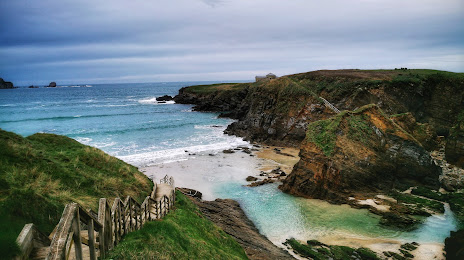
Photo
Where is located Ermida de Santa Comba
Ermida de Santa Comba — local attraction, which is located at 15594 Ferrol, A Coruña, Spain and belongs to the category — chapel. Average visitor rating for this place — 4.7 (according to 206 ratings, information from open sources and relevant for 2022).
Exact location — Ermida de Santa Comba, marked on the map with a red marker.
You can get directions to Ermida de Santa Comba on the map from your location.
What else is interesting in Ferrol? You can see all the sights if you go to the city page.
Coordinates
Ermida de Santa Comba, Spain coordinates in decimal format: latitude — 43.55961159282901, longitude — -8.28334567495583. When converted to degrees, minutes, seconds Ermida de Santa Comba has the following coordinates: 43°33′34.6 north latitude and -8°17′0.04 east longitude.
Nearby cities
The largest cities that are located nearby:
- A Coruña — 21 km
- Ourense — 131 km
- Vigo — 144 km
- Oviedo — 191 km
- Gijón — 205 km
- Braga
 (Portugal) — 216 km
 - León — 237 km
- Porto (Portugal) — 260 km
- Salamanca — 351 km
- Valladolid — 353 km
- Santander — 354 km
- Coimbra (Portugal) — 364 km
- Burgos — 391 km
- Bilbao — 426 km
- Vitoria-Gasteiz — 454 km
- Logroño — 484 km
- San Sebastián — 502 km
- Alcobendas — 505 km
- Móstoles — 507 km
Distance to the capital
Distance to the capital (Madrid) is about — 515 km.