
 Puerto de la Duquesa
La Serna de Iguña
Pumalverde
Puentenansa
La Iglesia
Casar de Periedo
Fuengirola
Renedo de Piélagos
Villabanez
Puerto de la Duquesa
La Serna de Iguña
Pumalverde
Puentenansa
La Iglesia
Casar de Periedo
Fuengirola
Renedo de Piélagos
Villabanez
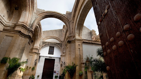
Parroquia Mayor De Santa Cruz on the map, Écija, Spain
Photo
Where is located Parroquia Mayor De Santa Cruz
Parroquia Mayor De Santa Cruz — local attraction, which is located at Plaza Ntra. Sra. del Valle, 5, 41400 Écija, Sevilla, Spain and belongs to the category — parish. Average visitor rating for this place — 4.5 (according to 276 ratings, information from open sources and relevant for 2022).
Exact location — Parroquia Mayor De Santa Cruz, marked on the map with a red marker.
You can get directions to Parroquia Mayor De Santa Cruz on the map from your location.
What else is interesting in Écija? You can see all the sights if you go to the city page.
Coordinates
Parroquia Mayor De Santa Cruz, Spain coordinates in decimal format: latitude — 37.5434223991874, longitude — -5.080800475139563. When converted to degrees, minutes, seconds Parroquia Mayor De Santa Cruz has the following coordinates: 37°32′36.32 north latitude and -5°4′50.88 east longitude.
Nearby cities
The largest cities that are located nearby:
- Córdoba — 47 km
- Dos Hermanas — 79 km
- Málaga — 108 km
- Marbella — 115 km
- Jaén — 116 km
- Jerez — 132 km
- Granada — 137 km
- Cádiz — 155 km
- Algeciras — 158 km
- Huelva — 167 km
- Tangier
 (Morocco) — 208 km
 - Badajoz — 220 km
- Tetouan (Morocco) — 220 km
- Almería — 245 km
- Albacete — 320 km
- Fuenlabrada — 322 km
- Móstoles — 324 km
- Getafe — 326 km
- Nador (Morocco) — 327 km
Distance to the capital
Distance to the capital (Madrid) is about — 341 km.