Elbridge — Gibbon
Elbridge — Omaha
Elbridge — Wilmot
Elbridge — Wellington
Elbridge — Maplesville
Elbridge — Pecatonica
Elbridge — Rushland
Elbridge — Moline
Elbridge — Sahuarita
Elbridge — Raleigh
Elbridge — Darlington
Elbridge — Oliver
Elbridge — Pleasant Mount
Elbridge — Barr
Elbridge — Orwell
Elbridge — Estelline
Elbridge — Kentland
Elbridge — Donner
Elbridge — Sophia
Liverpool
Syracuse
North Syracuse
East Syracuse
Fayetteville
Chittenango
Canastota
Oneida
Verona
Oriskany
Whitesboro
Utica
Ilion
Mohawk
Herkimer
Palatine Bridge
Fultonville
Amsterdam Airfield
Amsterdam
Hagaman
Galway
Malta
Saratoga Springs
Glens Falls
Queensbury
Fort Ann
Hampton
Hydeville
Castleton
Rutland
Killington
Bridgewater Corners
Woodstock
Taftsville
West Lebanon
Hanover
Norwich
East Thetford
Fairlee
Orford
Piermont
South Ryegate
East Ryegate
Littleton
Bethlehem
Twin Mountain
Whitefield
Gorham
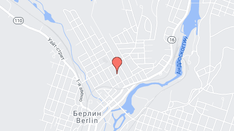
Elbridge — Berlin distance, route on the map
Distance by car
Distance between Elbridge, New York, United States and Berlin, New Hampshire, United States by car is — km, or miles. To travel this distance by car, you need minute, or h.
Route on the map, driving directions
Car route Elbridge — Berlin was created automatically. The road on the map is shown as a blue line. By moving the markers, you can create a new route through the points you need.
Passing cities through which the car route passes: Van Buren, Liverpool, Syracuse, North Syracuse, East Syracuse, Fayetteville, Chittenango, Canastota, Oneida, Verona, Oriskany, Whitesboro, Utica, Ilion, Mohawk, Herkimer, Palatine Bridge, Fultonville, Amsterdam Airfield, Amsterdam, Hagaman, Galway, Malta, Saratoga Springs, Glens Falls, Queensbury, Fort Ann, Hampton, Hydeville, Castleton, Rutland, Killington, Bridgewater Corners, Woodstock, Taftsville, West Lebanon, Hanover, Norwich, East Thetford, Fairlee, Orford, Piermont, South Ryegate, East Ryegate, Littleton, Bethlehem, Twin Mountain, Whitefield, Gorham.
Distance by plane
If you decide to take a trip Elbridge Berlin by plane, then you have to fly the distance — 452 km or 280 miles. It is marked on the map with a gray line (between two points in a straight line).
Flight time
Estimated flight time Elbridge Berlin by plane at cruising speed 750 km / h will be — 36 min.
Direction of movement
United States, Elbridge — right-hand traffic. United States, Berlin — right-hand traffic.
Difference in time
Elbridge and Berlin are in the same time zone. Between them there is no time difference (UTC -4 America/New_York).
Interesting Facts
Information on alternative ways to get to your destination.
The length of this distance is about 1.1% of the total length of the equator.
The percentage of the population is clearly shown in the graph:
Elbridge — 1,077 (less by 8,974), Berlin — 10,051 residents.
The cost of travel
Calculate the cost of the trip yourself using the fuel consumption calculator, changing the data in the table.